
Image by jdblack on Pixabay · Pixabay License
Upheaval Dome
Sign in to savelandform in Canyonlands National Park, Utah
In the Vinony graph
Vinony's link graph records 15 inbound references to Upheaval Dome, and connects out to United States, Utah and NASA.
The entry is geolocated on the map in UT.
Vinony files it under Canyonlands National Park, Impact craters of the United States and Jurassic impact craters.
Vinony links it to 5 Wikipedia language editions.
Described at
Upheaval Dome (U.S. National Park Service)
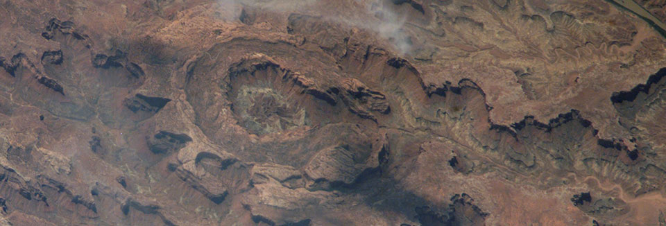
In an area approximately three miles (5 km) across, rock layers are dramatically deformed. What caused these folds at Upheaval Dome? Geologists do not know for sure, but two main theories are hotly debated.
nps.gov →Official websites use .gov A .gov website belongs to an official government organization in the United States. Secure .gov websites use HTTPS A lock ( Lock Locked padlock icon ) or means you've safely connected to the .gov website. Share sensitive information only on official, secure websites. Courtesy of the Earth Science and Remote Sensing Unit, NASA Johnson Space Center. ISS015-E-5983 Canyonlands is a place of relative geologic order. Layers of sedimentary deposits systematically record chapters in the park's past. With some exceptions, these layers have not been altered, tilted or folded significantly in the millions of years since they were laid down by ancient seas, rivers or winds. Upheaval Dome is quite a different story. In an area approximately three miles (5 km) across, rock layers are dramatically deformed. In the center, the rocks are pushed up into a circular structure called a dome, or an anticline. Surrounding this dome is a downwarp in the rock layers called a syncline. What caused these folds at Upheaval Dome? Geologists do not know for sure, but there are two main theories which are hotly debated. The uplifted syncline sits in the middle of the larger Upheaval Dome crater. A thick layer of salt, formed by the evaporation of ancient landlocked seas, underlies much of southeastern Utah and Canyonlands National Park. When under pressure from thousands of feet of overlying rock, the salt can flow plastically, like ice moving at the bottom of a glacier. In addition, salt is less dense than sandstone. As a result, over millions of years salt can flow up through rock layers as a "salt bubble", rising to the surface and creating salt domes that deform the surrounding rock. When meteorites collide with the earth, they leave impact craters like the well-known one in Arizona. Some geologists estimate that roughly 60 million years ago, a meteorite with a diameter of approximately one-third of a mile hit at what is now the Upheaval Dome. The impact created a large explosion, sending dust and debris high into the atmosphere. The impact initially created an unstable crater that partially collapsed. As the area around Upheaval Dome reached an equilibrium, the rocks underground heaved upward to fill the void left by the impact. Erosion since the impact has washed away any meteorite debris, and now provides a glimpse into the interior of the impact crater, exposing rock layers once buried thousands of feet underground. Read more about hiking at Island in the Sky, including the trails around Upheaval Dome.
Excerpt from a page describing this subject · 8,385 chars · not written by Vinony
Wikidata facts
- Instance of
- landform
- Country
- United States
- Located in
- San Juan County
- Image
- Upheaval Syncline campsite.jpg
Show 3 more facts
- Commons category
- Upheaval Dome
- located in protected area
- Canyonlands National Park
- described at URL
- www.nps.gov/articles/cany-upheaval-dome.htm
Sources (1)
via Wikidata · CC0