Category
page 1Astronomical coordinate systems

equator
thumb|150px|right|The equator (yellow line) at the December solstice. The direction of the Sun is to the left.
thumb|upright=1.35|Countries and territories that are intersected by the equator (red) or the IERS Reference Meridian|Prime Meridian (blue), which intersect at "[[Null Island".]]
The equator is the circle of latitude that divides Earth into the Northern and Southern Hemispheres. It is an imaginary line located at 0 degrees latitude, about in circumference, halfway between the North and South Poles. The term can also be used for any other celestial body that is roughly spherical.

horizon
thumb|right|300px|True, visible, and astronomical horizons. Not shown: refracted horizon.
Most commonly, the horizon is the border between the surface of a celestial body and its sky when viewed from the perspective of an observer on or above the surface of the celestial body. This concept is further refined as -
thumb|right|The curvature of the horizon as observed from a Space Shuttle at an altitude of .
The true or geometric horizon, which an observer would see if there was no alteration from refraction or from obstruction by intervening objects. The geometric horizon assumes a spherical ea
.png)
zodiac
The zodiac is a belt-shaped region of the sky that extends approximately 8° north and south celestial latitude of the ecliptic – the apparent path of the Sun across the celestial sphere over the course of the year. Within this zodiac belt appear the Moon and the brightest planets, along their orbital planes. The zodiac is divided along the ecliptic into 12 equal parts, called "signs", each occupying 30° of celestial longitude. These signs roughly correspond to the astronomical constellations with the following modern names: Aries, Taurus, Gemini, Cancer, Leo, Virgo, Libra, Scorpio, Sagittarius

ecliptic
thumb|upright=1.3|As seen from the orbiting Earth, the [[Sun appears to move with respect to the fixed stars, and the ecliptic is the yearly path the Sun follows on the celestial sphere. This process repeats itself in a cycle lasting a little over 365 days.]]

zenith
thumb|upright=1.25|right|Diagram showing the relationship between the zenith, the nadir, and different types of [[horizon]]
The zenith (, ) is the imaginary point on the celestial sphere directly "above" a particular location. "Above" means in the vertical direction (plumb line) opposite to the gravity direction at that location (nadir). The zenith is the "highest" point on the celestial sphere. The direction opposite of the zenith is the nadir.

geocentric model
thumb|upright=1.35|Figure of the heavenly bodies – An illustration of a Ptolemaic geocentric system by Portuguese cosmographer and cartographer Bartolomeu Velho, 1568 (Bibliothèque Nationale, Paris)

celestial sphere
imaginary sphere of arbitrarily large radius, concentric with the observer

right ascension
astronomical equivalent of longitude

declination
In astronomy, declination (abbreviated dec; symbol δ) is one of the two angles that locate a point on the celestial sphere in the equatorial coordinate system, the other being hour angle. The declination angle is measured north (positive) or south (negative) of the celestial equator, along the hour circle passing through the point in question.

year zero
year that does not exist in the Anno Domini / Common Era year-numbering system

celestial equator
projection of the Earth's equator out into space
nadir
thumb|300px|right|Diagram showing the relationship between the zenith, the nadir, and different types of [[horizon. Note that the zenith is opposite the nadir.]]

astronomical coordinate system
spherical coordinate system
celestial pole
two imaginary points in the sky where the Earth's axis of rotation, indefinitely extended, intersects the imaginary rotating sphere of stars called the celestial sphere

equatorial coordinate system
celestial coordinate system used to specify the positions of celestial objects
galactic coordinate system
celestial coordinate system in spherical coordinates, with the Sun as its center

ecliptic coordinate system
celestial coordinate system used for representing the positions of Solar System objects
sidereal year
time taken by the Earth to orbit the Sun once with respect to the fixed stars
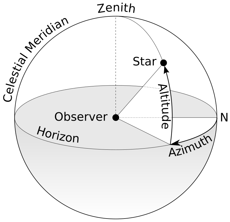
horizontal coordinate system
type of celestial coordinate system that uses the observer's local horizon as the fundamental plane
celestial meridian
great circle passing through the celestial poles, the zenith, and the nadir of a particular location

circumpolar star
star that never sets
first point of Aries
point on the celestial sphere
hour angle
unit of angle
barycenter
center of mass of two or more bodies that are orbiting each other, or the point around which they both or all orbit
subsolar point
point on the surface of a planet where the sun's rays strike the planet exactly perpendicular to its surface
.svg)
Almucantar
right|thumb|250px|The celestial sphere with the [[zenith and almucantar marked in red, the horizon in green, and the path of a star or the Sun in blue.]]An almucantar (also spelled almucantarat or almacantara) is a circle on the celestial sphere parallel to the horizon. Two stars that lie on the same almucantar have the same altitude.
The term was introduced into European astronomy by monastic astronomer Hermann Contractus of Reichenau, Latinized from the Arabic word ' ("the almucantar, sundial", plural: '), derived from '''' ("arch, bridge")
Northern celestial hemisphere
Northern half of the celestial sphere
position angle
measurement relating to observed visual binary stars
Southern Celestial Hemisphere
southern half of the celestial sphere

Colure
thumb|upright=1.3|Orange = equinoctial colure Blue = solstitial colure
thumb|G = equinoctial colure H = solstitial colure
Colure, in astronomy, is either of the two principal meridians of the celestial sphere. The term is now rarely used and may be considered obsolete.
ECEF
Earth-centered, Earth-fixed reference frame
International Celestial Reference System
celestial reference system using reference celestial sources observed at radio wavelengths
invariable plane
plane passing through the barycenter of a planetary system, perpendicular to its angular momentum vector
supergalactic coordinate system
coordinate system
Hour circle
Part of celestial coordinate system
equinox point
point defined via celestial coordinates
rotating reference frame
special case of a non-inertial reference frame that is rotating relative to an inertial reference frame
ecliptic pole
direction of imaginary projection onto the remote celestial sphere of the line perpendicular to planet Earth's orbital plane and passing though the orbital center
galactic quadrant
one of four circular sectors in the division of the Milky Way Galaxy

Vertical circle
great circle perpendicular to the mathematical horizon
Gaussian year
unit of time equaling 365.2568983 days, adopted by Carl Friedrich Gauss as the length of the sidereal year in his studies of the dynamics of the solar system
Poles of astronomical bodies
Celestial coordinate system
Prime vertical
Celestial coordinate system
Polar distance
Celestial coordinate system
parallactic angle
the angle between the great circle through a celestial object and the zenith, and the hour circle of the object
planetary coordinate system
Celestial coordinate system