Category
page 1Oceanography

ocean
The ocean is the body of salt water that covers approximately 70.8% of Earth. The ocean is conventionally divided into large bodies of water, which are also referred to as oceans (in descending order by area: the Pacific Ocean, the Atlantic Ocean, the Indian Ocean, the Antarctic/Southern Ocean, and the Arctic Ocean), and are themselves mostly divided into seas, gulfs and subsequent bodies of water. The ocean contains 97% of Earth's water and is the primary component of Earth's hydrosphere, acting as a huge reservoir of heat for Earth's energy budget, as well as for its carbon cycle and water c

ice
Ice is water that is frozen into a solid state, typically forming at or below temperatures of 0 °C, 32 °F, or 273.15 K. It occurs naturally on Earth, on other planets, in Oort cloud objects, and as interstellar ice. As a naturally occurring crystalline inorganic solid with an ordered structure, ice is considered to be a mineral. Depending on the presence of impurities such as particles of soil or bubbles of air, it can appear transparent or a more or less opaque bluish-white color.

meteorology
Meteorology is the scientific study of the Earth's atmosphere and short-term atmospheric phenomena (i.e., weather), with a focus on weather forecasting. It has applications in the military, aviation, energy production, transport, agriculture, construction, weather warnings, and disaster management.

water cycle
continuous movement of water on, above and below the surface of the Earth

oceanography
thumb|Thermohaline circulation

biosphere
thumb|A false color composite of global oceanic and terrestrial photoautotroph abundance, from September 2001 to August 2017. Provided by the [[SeaWiFS Project, NASA/Goddard Space Flight Center and ORBIMAGE.]]
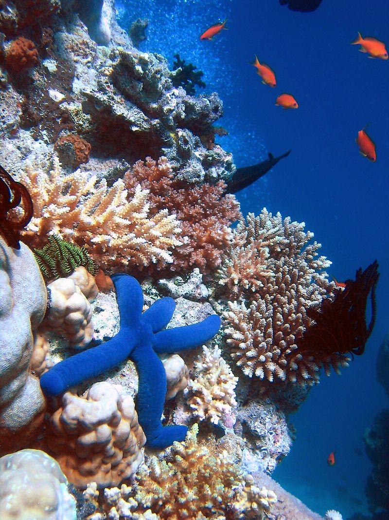
coral reef
ridge of rock in the sea formed by the growth and deposit of coral

Labrador Sea
sea

hydrography
thumb|right|upright=1.3|Table of geography, hydrography, and navigation, from a 1728 Cyclopaedia, or an Universal Dictionary of Arts and Sciences|Cyclopaedia
Hydrography is the branch of applied sciences which deals with the measurement and description of the physical features of oceans, seas, coastal areas, lakes and rivers, as well as with the prediction of their change over time, for the primary purpose of safety of navigation and in support of all other marine activities, including economic development, security and defense, scientific research, and environmental protection.

salinity
thumb|upright=1.3|right|Annual mean sea surface salinity for the World Ocean. Data from the [[World Ocean Atlas 2009.]]
thumb|upright|right|International Association for the Physical Sciences of the Oceans (IAPSO) standard seawater.
Salinity () is the saltiness or amount of salt dissolved in a body of water, called saline water (see also soil salinity). It is usually measured in g/L or g/kg (grams of salt per liter/kilogram of water; the latter is dimensionless and equal to ‰).

pelagic zone
any water that is neither close to the bottom nor near the shore

seabed
thumb|Common stingray foraging for [[invertebrates in seafloor sediment.]]

littoral zone
part of a sea, lake or river that is close to the shore
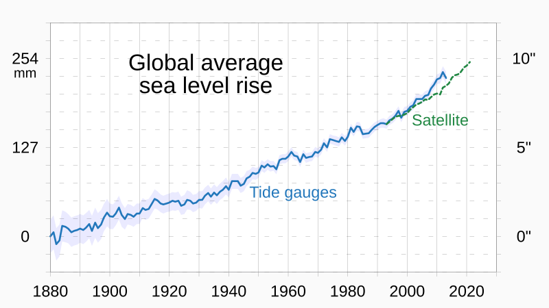
sea level rise
current long-term trend for global sea levels to rise mainly in response to climate change

Club of Rome
political and economic think tank
ocean acidification
climate change-induced decline of pH levels in the ocean

advection
In the fields of physics, engineering, and earth sciences, advection is the transport of a substance or quantity by bulk motion of a fluid. The properties of that substance are carried with it. Generally the majority of the advected substance is also a fluid. The properties that are carried with the advected substance are conserved properties such as energy. An example of advection is the transport of pollutants or silt in a river by bulk water flow downstream. Another commonly advected quantity is energy or enthalpy. Here the fluid may be any material that contains thermal energy, such as wat
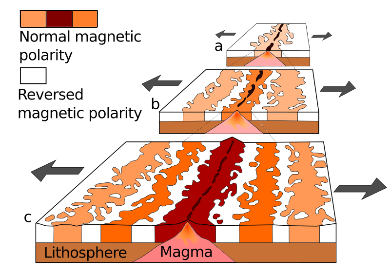
submarine geology
study of the history and structure of the ocean floor

bathymetry
thumb|upright=1.7|
thumb|right|Animation reveals oceanic floors and seabeds. Continental shelves appear mostly by a depth of 140 meters, [[mid-ocean ridges by 3000 meters, and oceanic trenches at depths beyond 6000 meters.]]
thumb|right|A seafloor map captured by NASA

thermocline
thumb|Graph showing a tropical ocean thermocline (depth vs. temperature). Note the rapid change between 100 and 1000 meters. The temperature is nearly constant after 1500 meters depth.

upwelling
Upwelling is an oceanographic phenomenon that involves wind-driven motion of dense, cooler, and usually nutrient-rich water from deep water towards the ocean surface. It replaces the warmer and usually nutrient-depleted surface water. The nutrient-rich upwelled water stimulates the growth and reproduction of primary producers such as phytoplankton. The biomass of phytoplankton and the presence of cool water in those regions allow upwelling zones to be identified by cool sea surface temperatures (SST) and high concentrations of chlorophyll a.
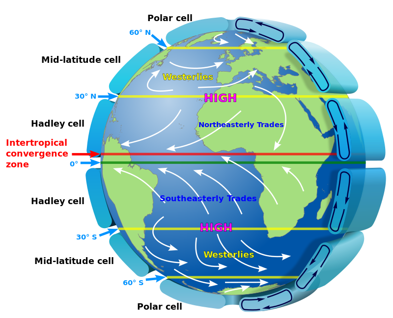
Hadley cell
tropical atmospheric circulation feature

Earth's energy budget
accounting of the energy flows which determine Earth's surface temperature and drive its climate
Cagados Carajos
atoll
properties of water
overview about physical and chemical properties of pure water
East Greenland Current
cold, low salinity current that extends from Fram Strait to Cape Farewell off the eastern coat of Greenland
rogue wave
relatively large and spontaneous ocean surface waves that occur far out at sea
list of seas
Wikimedia list article
Musée océanographique de Monaco
museum of marine sciences
aphotic zone
portion of a lake or ocean where less than 1% of sunlight penetrates
manganese nodule
rock concretion on the sea bottom made of layers of iron/manganese hydroxides

Bloop
thumb|A spectrogram of Bloop
Bloop was an ultra low frequency, high-amplitude underwater sound detected by the U.S. National Oceanic and Atmospheric Administration (NOAA) in 1997. By 2012, earlier speculation that the sound originated from a marine animal was replaced by NOAA's description of the sound as being consistent with noises generated via non-tectonic cryoseisms originating from glacial movements such as ice calving, or through seabed gouging by ice.
sea surface temperature
water temperature close to the ocean's surface
drift ice
sea ice that is not attached to land but rather moves on the sea surface in response to wind and ocean currents

hydrometeorology
alt=Watercycle-french.jpg|thumb|Watercycle-french.jpg
Hydrometeorology is a branch of meteorology and hydrology that studies the transfer of water and energy between the land surface and the lower atmosphere for academic research, commercial gain or operational forecasting purposes.
sverdrup
In oceanography, the sverdrup (symbol: Sv) is a non-SI metric unit of volumetric flow rate, with equal to , or equivalently 1 cubic hectometer per second (symbol: hm3/s or hm3⋅s−1). It is used almost exclusively in oceanography to measure the volumetric rate of transport of ocean currents. It is named after Harald Sverdrup.
bathyal zone
part of the pelagic zone that extends from a depth of 1000 to 4000 meters (3300 to 13000 feet) below the ocean surface. It lies between the mesopelagic above, and the abyssopelagic below
Ekman spiral
structure of currents or winds near a horizontal boundary in which the flow direction rotates as one moves away from the boundary
Atlantic meridional overturning circulation
zonally-integrated component of surface and deep currents in the Atlantic Ocean
anoxic event
intervals in the Earth's past
Operation Highjump
United States Navy operation
continental rise
underwater feature found between the continental slope and the abyssal plain
marine protected area
protected areas of seas, oceans, estuaries or large lakes
sea state
general condition of the free surface on a large body of water
marine sediment
sediment from marine waters
mesopelagic zone
part of the pelagic zone

downwelling
thumb|Schematic of coastal downwelling in the Northern Hemisphere.|300x300pxDownwelling is the downward movement of a fluid parcel and its properties (e.g., salinity, temperature, pH) within a larger fluid. It is closely related to upwelling, the upward movement of fluid.
Ekman transport
net transport of surface water perpendicular to wind direction
United States Exploring Expedition
exploring and surveying expedition, 1838 to 1842
ocean heat content
thermal energy stored in ocean water
terrigenous sediment
sediments derived from the erosion of rocks on land
marine habitat
habitat that supports marine life
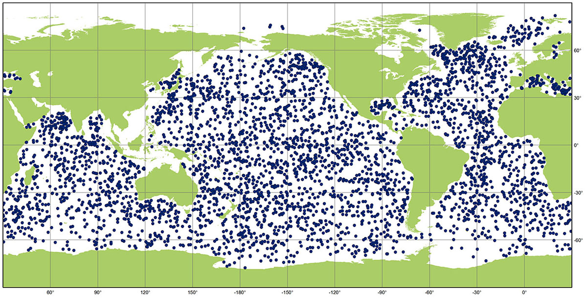
Argo
oceanographic observation system
Aquarius Reef Base
underwater habitat
Deep-sea exploration
investigation of conditions on the sea bed, for scientific or commercial purposes
fetch
the length of water over which a given wind has blown
SOFAR channel
horizontal layer of water in the ocean at which depth the speed of sound is at its minimum
tidal range
vertical difference between the high tide and the succeeding low tide
Coriolis frequency
equal to twice the rotation rate Ω of the Earth multiplied by the sine of the latitude φ
subaquaria
realm below the surface of water