Category
page 1Plate tectonics

volcano
thumb|upright=1.35|Augustine Volcano (Alaska) during its eruptive phase on January 24, 2006

plate tectonics
scientific theory that describes the large-scale motions of Earth's lithosphere
.png)
Pangaea
thumb|270x270px|Map of Pangaea around 250 million years ago, at the beginning of the Triassic
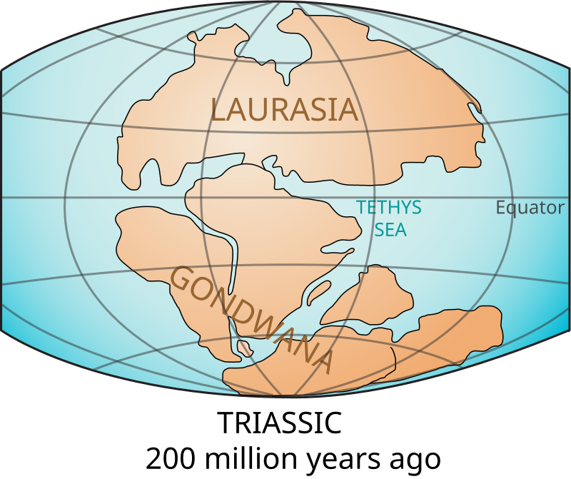
Pangaea or Pangea ( ) was a supercontinent that existed during the late Paleozoic and early Mesozoic eras. It assembled from the earlier continental units of Gondwana, Euramerica and Siberia during the Carboniferous period approximately 335 million years ago, and began to break apart about 200 million years ago, at the end of the Triassic and beginning of the Jurassic. Pangaea was C-shaped, with the bulk of its mass stretching between Earth's northern and southern polar regions and surrounded by the s

lithosphere
thumb|upright=1.35|The tectonic plates of the lithosphere on Earth
thumb|upright=1.35|Earth cutaway from center to surface, the lithosphere comprising the crust and lithospheric mantle (detail not to scale)

Pacific Ring of Fire
region at edges of Pacific Ocean known for tectonic activity

asthenosphere
300px|thumb|upright=1.6|The asthenosphere shown at a subduction boundary
Tethys Ocean
prehistoric ocean

supercontinent
thumb|upright=1.35|The supercontinent of Pangaea with the positions of the continents at the [[Permian-Triassic boundary, about 250 Ma. AR=Amuria; NC=North China; SC=South China; PA=Panthalassic Ocean; PT=Paleotethys Ocean; NT=Neotethys Ocean. Orogens shown in red. Subduction zones shown in black. Spreading centers shown in green.]]
thumb|Although not a supercontinent, the current Afro-Eurasian landmass contains about 57% of Earth's land area.

continental drift
movement of Earth's continents relative to each other
mid-ocean ridge
basaltic underwater mountain system formed by plate tectonic spreading

subduction
thumb|upright=1.85|Diagram of the geological process of subduction

oceanic trench
depressions of the sea floor

orogeny
thumb|Map of the last orogenies to affect Earth's geologic provinces

Rodinia
thumb|Reconstruction of Rodinia at 900 million years ago, using modern images to illustrate where today's recognisable continents were at the time.
Rodinia (from the Russian родина, rodina, meaning "motherland, birthplace") was a Mesoproterozoic and Neoproterozoic supercontinent that assembled 1.26–0.90 billion years ago (Ga) and broke up 750–633 million years ago (Ma). were probably the first to recognise a Precambrian supercontinent, which they named "Pangaea I". It was renamed "Rodinia" by , who also were the first to produce a plate reconstruction and propose a temporal framework for the s

hotspot
volcanic region

Mohorovičić discontinuity
term in geography: boundary between the Earth's crust and the mantle

rift
thumb|Block view of a rift formed cut
of three segments, showing the location of the accommodation zones between them at changes in fault location or polarity (dip direction).
upright|thumb|Gulf of Suez Rift showing main [[extensional faults]]

oceanic crust
part of Earth's lithosphere
seafloor spreading
process at mid-ocean ridges, where new oceanic crust is formed through volcanic activity and then gradually moves away from the ridge

Pannotia
thumb|Pannotia was centred on the South Pole, hence its name.
Pannotia (from Greek: pan-, "all", -nótos, "south"; meaning "all southern land"), also known as the Vendian supercontinent, Greater Gondwana, and the Pan-African supercontinent, was a relatively short-lived Neoproterozoic supercontinent that formed at the end of the Precambrian during the Pan-African orogeny (650–500 Ma), during the Cryogenian period, and broke apart 560 Ma with the opening of the Iapetus Ocean, in the late Ediacaran and early Cambrian.
Pannotia formed when Laurentia was located adjacent to the two major South Ameri

Panthalassa
thumb|upright=1.3|The Panthalassa superocean 250 million years ago
thumb|upright=1.3|The supercontinent Pangaea in the early Mesozoic (at 200 Ma) surrounded by Panthalassa.
thumb|upright=1.3|The Pacific Plate began forming when the [[triple junction at the center of Panthalassa destabilized about 190 million years ago.]]
Panthalassa, also known as the Panthalassic Ocean or Panthalassan Ocean (from Greek "all" and "sea"), was the vast superocean that encompassed planet Earth and surrounded the supercontinent Pangaea, the latest in a series of supercontinents in the history of Earth. During the
island arc
arc-shaped archipelago

Chersky Range
mountain range

continental crust
layer of rocks that forms the continents and continental shelves

shield
large, tectonically stable formation of Precambrian crystalline rock

guyot
thumb|right|350px|The Bear Seamount (left), a guyot in the northern [[Atlantic Ocean]]
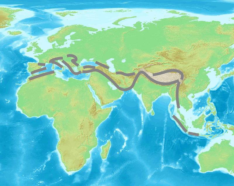
Alpide belt
seismic and orogenic belt that includes an array of mountain ranges extending for more than 15'000 km along the southern margin of Eurasia

ophiolite
thumb|Ordovician ophiolite in Gros Morne National Park, Newfoundland
thumb|Chromitic serpentinite, Bay of Islands Ophiolite, Lewis Hills, Newfoundland
thumb|Chromitite ore with chromite (black) & talc and/or antigorite (whitish). Shetland Ophiolite Complex, ~425-500 Ma. [[Shetland Islands, North Sea, UK]]

geodynamics
Geodynamics is a subfield of geophysics dealing with dynamics of the Earth. It applies physics, chemistry and mathematics to the understanding of how mantle convection leads to plate tectonics and geologic phenomena such as seafloor spreading, mountain building, volcanoes, earthquakes, or faulting. It also attempts to probe the internal activity by measuring magnetic fields, gravity, and seismic waves, as well as the mineralogy of rocks and their isotopic composition. Methods of geodynamics are also applied to exploration of other planets.

Baltica
thumb|upright=1.35|Baltica (in white, at the centre of the image, with outline of present-day Europe for reference)
Baltica is a paleocontinent that formed in the Paleoproterozoic and now constitutes northwestern Eurasia, or Europe north of the Trans-European Suture Zone and west of the Ural Mountains.
The thick core of Baltica, the East European Craton, is more than three billion years old and formed part of the Rodinia supercontinent at 1 .
future of Earth
possible upcoming scenarios for Earth
convergent boundary
area where two tectonic plate collide
thrust fault
a type of reverse fault that has a dip of 45 degrees or less
East Pacific Rise
mid-oceanic ridge
Vaalbara
Vaalbara is a hypothetical Archean supercontinent consisting of the Kaapvaal craton (in present-day eastern South Africa) and the Pilbara Craton (in present-day north-western Western Australia). E. S. Cheney derived the name from the last four letters of each craton's name. The two cratons consist of continental crust dating from 3.6 to 2.7 Ga; this timing would make Vaalbara one of Earth's earliest supercontinents.
crust
outermost solid shell of a rocky planet, dwarf planet or natural satellite, which is chemically distinct from the underlying mantle

dunite
thumb|right|upright=1.2|Small volcanic bomb of (black) [[basanite with (green) dunite]]
transform boundary
plate boundary where the motion is predominantly horizontal
Wadati–Benioff zone
planar zone of seismicity corresponding with the down-going slab
Deccan Traps
large igneous province located on the Deccan Plateau
volcanic arc
chain of volcanoes formed above a subducting plate
divergent boundary
linear feature that exists between two tectonic plates that are moving away from each other
North Anatolian Fault
geological fault
platform
continental area covered by relatively flat or gently tilted, mainly sedimentary strata
marine regression
geological process of areas of submerged seafloor being exposed above the sea level
Cayman Trough
complex transform fault zone pull-apart basin on the floor of the western Caribbean Sea
volcanic belt
range of volcanically active mountains
megathrust earthquake
earthquakes that occur at subduction zones at destructive convergent plate boundaries, where one tectonic plate is forced underneath another. These earthquakes are the planet's most powerful, with moment magnitudes (Mw) that can exceed 9.0
obduction
Obduction is a geological process whereby denser oceanic crust (and even upper mantle) is scraped off a descending ocean plate at a convergent plate boundary and thrust on top of an adjacent plate. When oceanic and continental plates converge, normally the denser oceanic crust sinks under the continental crust in the process of subduction. Obduction, which is less common, normally occurs in plate collisions at orogenic belts (some of the material from the subducting oceanic plate is emplaced onto the continental plate) or back-arc basins (regions where the edge of a continent is pulled away fr

nappe
thumb|right|350px|Schematic overview of an eroded thrust system. The shaded material is the nappe. The erosional hole is called a window (geology)|window or fenster. The [[klippe is the isolated block of the nappe overlying autochthonous material.]]
In geology, a nappe or thrust sheet is a large sheetlike body of rock that has been moved more than or above a thrust fault from its original position. Nappes form in compressional tectonic settings like continental collision zones or on the overriding plate in active subduction zones. Nappes form when a mass of rock is forced (or "thrust") over an
Caroline Plate
tectonic plate
triple junction
point where the boundaries of three tectonic plates meet
oceanic plateau
relatively flat submarine region that rises well above the level of the ambient seabed
mantle convection
slow creeping motion of Earth's solid silicate mantle caused by convection currents carrying heat from the interior to the planet's surface.
greenstone belt
zone of variably metamorphosed (ultra)mafic volcanic sequences with associated sedimentary rocks occurring in Archaean and Proterozoic cratons between granite and gneiss bodies, typically dozens to thousands of kilometres long
Conrad discontinuity
discontinuous seismic boundary

superocean
right|200px|thumb|The supercontinent Pangaea surrounded by the superocean Panthalassa.
tectonic uplift
portion of the total geologic uplift of the mean earth surface that is not attributable to an isostatic response to unloading
back-arc basin
submarine features associated with island arcs and subduction zones
Mirovia
Mirovia or Mirovoi (from Russian мировой, mirovoy, meaning "global") was a hypothesized superocean which may have been a global ocean surrounding the supercontinent Rodinia in the Neoproterozoic Era, about 1 billion to 750 million years ago. Mirovia may be essentially identical to, or the precursor of, the hypothesized Pan-African Ocean, which followed the rifting of Rodinia. The Panthalassa (proto-Pacific) Ocean developed in the Neoproterozoic Era by subduction at the expense of the global Mirovia ocean.