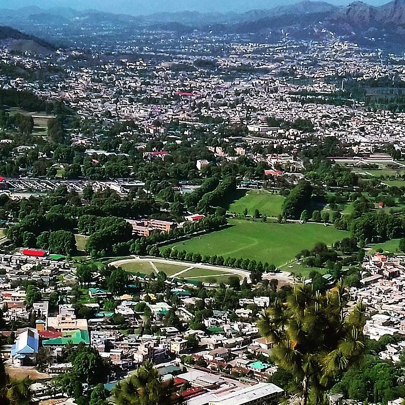
File:Abbottabad_City_view.jpg · Wikimedia Commons · See Wikimedia Commons
Abbottabad
Sign in to saveAbbottabad is a city in the Hazara Division of Khyber Pakhtunkhwa province, Pakistan. It is the 40th largest city in the country and 6th largest in the province by population, and serves as the headquarter of its namesake tehsil and district. It is about north of Islamabad-Rawalpindi and east of Peshawar, at an elevation of . Kashmir lies a short distance to the east.
Abbottabad is a major city in northern Pakistan's Khyber Pakhtunkhwa province, located between Islamabad and Peshawar at a high elevation near the Kashmir border. It is the 40th largest city in Pakistan and serves as the administrative headquarters for its district and tehsil.
AI-generated from the Wikipedia summary — may contain errors.
Weather now
7-day forecast
via Open-Meteo
Place details
- Locality
- ایبٹ آباد
- Region
- خیبر پختونخوا
- Country
- پاکستان
- Population
- 275,890
- Timezone
- Asia/Karachi
via OpenStreetMap · GeoNames
Key facts
- Settlement.official_name
- Abbottabad
- Settlement.native_name_lang
- ur
- Settlement.settlement_type
- City
- Settlement.image_skyline
- 250px125px 125px250px
- Settlement.image_caption
- From top, left to right: City view, Mushkpuri top, view of Abbottabad from Shimla Hill
- Settlement.mapsize
- 150px
- Settlement.pushpin_map
- Khyber Pakhtunkhwa#Pakistan#Asia
- Settlement.pushpin_mapsize
- 250
- Settlement.pushpin_map_caption
- Location within Khyber Pakhtunkhwa province##Location within Pakistan##Location within Asia
- Settlement.subdivision_type
- Country
- Settlement.subdivision_type1
- Province
- Settlement.subdivision_type2
- Division
- Settlement.subdivision_name2
- Hazara
- Settlement.subdivision_type3
- District
- Settlement.subdivision_name3
- Abbottabad
- Settlement.established_title
- Founded
- Settlement.established_date
- 1853
- Settlement.population_total
- 275,890
via Wikipedia infobox
Wikidata facts
- Instance of
- big city
- Official name
- ایبٹ آباد
- Country
- Pakistan
- Located in
- Abbottabad District
- Population
- 148587
- Elevation
- 1256
- Capital of
- Hazara Division
- Official website
- www.abbottabad.gov.pk
- Image
- Abbottabad View.JPG
- Dialing code
- 0992
Show 4 more facts
- Commons category
- Abbottabad
- inception
- 1853-00-00
- category of associated people
- Category:People from Abbottabad
- P12749
- musical
via Wikidata · CC0
Travel guide
Understand
thumb|Painting by James Abbott, near the town The town was founded as a British district headquarters and military base in the 1850s. It was named for the founder, Major James Abbott (later General Sir James Abbott).
At one time, the city was quite important as a transport hub, a stop on the main route north toward Gilgit and China. Its importance in this role has been somewhat diminished by the completion of the Karakoram Highway.
Get in
From Rawalpindi or Islamabad you can reach Abbottabad by road in less than 3 hours. Daewoo bus service operates more than three services daily for under Rs. 500 per passenger. It is an hour's drive from Nathia Gali which is about 34 km dropping steeply through the beautiful valleys with few trees to the river bed.
Abbottabad is the junction from where you can go to places like Hunza, Gilgit, Skardu and Indus Kohistan, of the Karakoram Range. You can reach Swat, Swati Kohistan, Dir and Chitral of the Hindu Kush. And approach Naran, Saif-ul-Muluk, Shogran and Babusar Pass of the Himalayan Range. Neelum, Lipa and Jhelum Valley of Azad Kashmir are also connected through Abbottabad.
There is no railway service to Abbottabad, trains terminate in Havelian which is about 30 minutes south of the city.
See
Mukeshpuri 9800 feet and Miranjani 9750 feet are its highest peaks. Ilysi Mosque, Shimla Pahari hill) Takaya Dodheyal Nawansheher Bazaar stairs Harno (tourist area with open water) Thandiani (~25 km) Dhamtoor Swinging Bridge near Harno
Do
Trekking, Hiking, Camping, Photography, Golf, Picnic
Abbottabad in addition to being a hill station has some of Pakistan's best educational institutions (e.g. Army Burn Hall School & College, Abbottabad Public School, International Public School, Ayub Medical College, Frontier Medical College, Hazara University). It has therefore become a leading learning seat in Pakistan.
Eat
Pakoras and fish at Ilyasi Masjid. A lot of people gather there to enjoy those tasty pakoras. Kebab of Qalandarabad. Pulaw opposite to AMC
Sleep
Sarban Hotel Jan's Continental Guest House Pearl Continental Motel Pine Inn Guest House Shelton Inn Guest House Snow Land Guest House Alaf Laila Guest House kaghan colony, opp usmania restaurant, 03459566871 Devgru Resort & Spa
Travel guide from Wikivoyage (CC BY-SA 4.0)
~18 min read
Encyclopedic overview
24 sectionsContents
- Etymology
- History
- Punjab Province
- North-West Frontier Province
- October 2005 earthquake
- Internally displaced people
- Arrest of Bali Bomber
- Osama bin Laden's hideout
- Impact of COVID-19
- Politics
- Demographics
- Population
- Religion
- Languages
- Location
- Climate
- Tourism
- Education
- Media
- Sports
- Transport
- Notes
- References
- External links
Abbottabad is a city in the Hazara Division of Khyber Pakhtunkhwa province, Pakistan. It is the 40th largest city in the country and 6th largest in the province by population, and serves as the headquarter of its namesake tehsil and district. It is about north of Islamabad-Rawalpindi and east of Peshawar, at an elevation of . Kashmir lies a short distance to the east.
==Etymology== The name combines the name of the city founder, Major James Abbott, and the Persian ending ābād, meaning "settlement, town of". Abbottabad is one of two cities named after British army officers in Pakistan, the other being Jacobabad.
Excerpted from Wikipedia’s “Abbottabad” article, available under the CC BY-SA 4.0 licence.
Gallery (50)
On the map
3 mapped locations
Available in 61 languages
- Español
- Français
- Deutsch
- 中文
- 日本語
- Русский
- Português
- Italiano
- العربية
- हिन्दी
- Awadhi
- Azerbaijani
- Bahasa Indonesia
- Bangla
- Bikol
- Catalan
- Cebuano
- Central Kurdish
Show 42 more
- Czech
- Danish
- Egyptian Arabic
- Esperanto
- Estonian
- Finnish
- Galician
- Georgian
- Greek
- Hebrew
- Hungarian
- Interlingue
- Javanese
- Kannada
- Lithuanian
- Malay
- Marathi
- Nederlands
- Nepali
- Norwegian
- Pashto
- Polski
- Punjabi
- Romanian
- Scots
- Serbian
- Sicilian
- simple
- Sindhi
- Svenska
- Tamil
- Tiếng Việt
- Türkçe
- Ukrainian
- Urdu
- Waray
- Western Frisian
- Western Panjabi
- Wu Chinese
- zh_yue
- فارسی
- 한국어
via Wikidata sitelinks · CC0