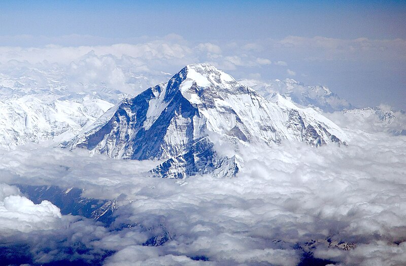
File:Dhaulagiri_-_view_from_aircraft.jpg · Wikimedia Commons · See Wikimedia Commons
Dhaulagiri
Sign in to saveAlso known as Dhwalagiri, Dhaulagiri I
Dhaulagiri, located in Nepal, is the seventh highest mountain in the world at above sea level, and the highest mountain within the borders of a single country. Dhaulagiri I is also the highest point of the Gandaki river basin. It was first climbed on 13 May 1960 by a Swiss-Austrian-Nepali expedition. Annapurna I () is east of Dhaulagiri. The Kali Gandaki River flows between the two in the Kali Gandaki Gorge, the world's deepest. The town of Pokhara is south of the Annapurnas, an important regional center and the gateway for climbers and trekkers visiting both ranges as well as a tourist destin
Dhaulagiri is Nepal's seventh-highest mountain in the world and the tallest mountain contained entirely within a single country's borders. It holds significance both as a major mountaineering objective—first summited in 1960—and as the highest point of the Gandaki river basin, located in a dramatic region between deep gorges and popular trekking destinations.
AI-generated from the Wikipedia summary — may contain errors.
Key facts
- Mountain.name
- Dhaulagiri
- Mountain.photo
- Dhaulagiri - view from aircraft.jpg
- Mountain.photo_caption
- Aerial view of Dhaulagiri I from the southwest.
- Mountain.elevation_m
- 8167
- Mountain.elevation_ref
- Ranked 7th
- Mountain.prominence_m
- 3357
- Mountain.prominence_ref
- Ranked 55th
- Mountain.parent_peak
- K2
- Mountain.range
- Dhaulagiri Himal
- Mountain.listing
- Eight-thousanderUltra
- Mountain.location
- Nepal
- Mountain.first_ascent
- 13 May 1960 by Kurt Diemberger, A. Schelbert, E. Forrer, Nawang Dorje, Nyima Dorje(First winter ascent 21 January 1985 Jerzy Kukuczka and Andrzej Czok)
- Mountain.easiest_route
- Northeast ridge
via Wikipedia infobox
Wikidata facts
- Instance of
- mountain
- Part of
- Himalayas
- Country
- Nepal
- Located in
- Gandaki Province
- Elevation
- 8167
- Image
- Dhaulagiri, Himalaya, Nepal.jpg
- Significant event
- first ascent
Show 8 more facts
- Commons category
- Dhaulagiri
- Commons gallery
- Dhaulagiri
- topographic prominence
- 3357
- topographic isolation
- 318
- parent peak
- K2
- mountain range
- Dhaulagiri Himal
- peak bagging classification
- eight-thousander
- described by source
- The Nuttall Encyclopædia
Sources (2)
via Wikidata · CC0
~9 min read
Encyclopedic overview
9 sectionsContents
- Toponymy
- Geography
- History
- Climbing history
- Partial timeline
- See also
- Sources
- Bibliography
- External links
Dhaulagiri, located in Nepal, is the seventh highest mountain in the world at above sea level, and the highest mountain within the borders of a single country. Dhaulagiri I is also the highest point of the Gandaki river basin. It was first climbed on 13 May 1960 by a Swiss-Austrian-Nepali expedition. Annapurna I () is east of Dhaulagiri. The Kali Gandaki River flows between the two in the Kali Gandaki Gorge, the world's deepest. The town of Pokhara is south of the Annapurnas, an important regional center and the gateway for climbers and trekkers visiting both ranges as well as a tourist destination in its own right.
== Toponymy == Dhaulagiri (धौलागिरी) is the Nepali name for the mountain which comes from Sanskrit where धवल (dhawala) means dazzling, white, beautiful and गिरि (giri) means mountain.
Excerpted from Wikipedia’s “Dhaulagiri” article, available under the CC BY-SA 4.0 licence.
Gallery (7)
On the map
56 mapped locations
Available in 86 languages
- Español
- Français
- Deutsch
- 中文
- 日本語
- Русский
- Português
- Italiano
- العربية
- हिन्दी
- Afrikaans
- Aragonese
- Armenian
- Asturian
- Azerbaijani
- Bahasa Indonesia
- Bangla
- Basque
Show 67 more
- Belarusian
- Bhojpuri
- Bosnian
- Bulgarian
- Catalan
- Cebuano
- Croatian
- Czech
- Danish
- dty
- Egyptian Arabic
- Esperanto
- Estonian
- Finnish
- Galician
- Georgian
- Greek
- Hungarian
- Icelandic
- Ido
- Javanese
- Kannada
- Kurdish
- Latin
- Latvian
- Lithuanian
- lld
- Lombard
- Macedonian
- Maithili
- Malay
- Malayalam
- Marathi
- Mingrelian
- Nederlands
- Nepali
- Norwegian
- Norwegian Nynorsk
- Occitan
- Piedmontese
- Polski
- Punjabi
- Romanian
- Scots
- Serbian
- Serbian (Latin)
- simple
- Slovak
- Slovenian
- Svenska
- Swahili
- Tajik
- Tamil
- Tiếng Việt
- Toki Pona
- Türkçe
- Ukrainian
- Urdu
- Uzbek
- Waray
- Welsh
- Western Panjabi
- Wu Chinese
- Xhosa
- فارسی
- ไทย
- 한국어
via Wikidata sitelinks · CC0