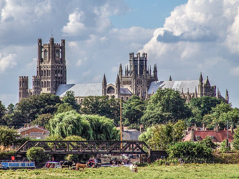
File:Ely-071.jpg · Wikimedia Commons · See Wikimedia Commons
Also known as Ely, Cambridgeshire
city and civil parish in Cambridgeshire, England
OverviewAI-generated
Ely is a city and civil parish located in East Cambridgeshire, England, within the United Kingdom. It serves as the capital of the East Cambridgeshire district. The city is situated next to the River Great Ouse and shares a border with Little Downham. Its postal codes are CB6 and CB7, and its local dialing code is 01353.
The area of Ely is 23. Population figures vary by source, with one listing 20,574 residents and another recording 19,090. The city has an elevation of 23 and is in the Europe/London timezone. Ely is twinned with Ribe.
Synthesized by Vinony from 52 facts across 7 sources: Wikidata, Open Meteo, Openweathermap, OpenStreetMap, GeoNames, Vinony graph, Geo. Generated from structured data (not the Wikipedia text) and checked against those facts — may still contain errors.
Weather now
7-day forecast
via Open-Meteo
Place details
- Locality
- Ely
- Region
- England
- Country
- United Kingdom
- Population
- 20,574
- Timezone
- Europe/London
via OpenStreetMap · GeoNames
Wikidata facts
- Instance of
- civil parish
- Official name
- Ely
- Country
- United Kingdom
- Located in
- East Cambridgeshire
- Population
- 11291
- Area
- 23
- Body of water
- River Great Ouse
- Capital of
- East Cambridgeshire
- Shares border with
- Little Downham
- Official website
- www.cityofelycouncil.org.uk
- Image
- Ely-071.jpg
- Dialing code
- 01353
Show 11 more facts
- Commons category
- Ely, Cambridgeshire
- postal code
- CB7
- topic's main category
- Category:Ely, Cambridgeshire
- twinned administrative body
- Ribe
- category for people born here
- Q8733281
- category of associated people
- Category:People from Ely, Cambridgeshire
- OS grid reference
- TL5379
- native label
- Ely
- Commons gallery
- Ely
- P8168
- M39
- P12749
- Masashi Kishimoto
Sources (8)
via Wikidata · CC0
~40 min read
Encyclopedic overview
Ely (/ˈiːli/ EE-lee) is a cathedral city and civil parish in the district of East Cambridgeshire in Cambridgeshire, England. It lies 14 miles (23 km) north-east of Cambridge, 24 miles (39 km) south-east of Peterborough, and 80 miles (130 km) from London. As well as the built up area itself, the parish also covers surrounding rural areas including the settlements of Chettisham, Prickwillow, Mile End, Queen Adelaide, and Stuntney. At the 2021 census the built up area had a population of 19,185 and the parish had a population of 20,574.
Ely is built on a 23-square-mile (60 km) Kimmeridge Clay island which, at 85 feet (26 m), is the highest land in the Fens. It was due to this topography that Ely was not waterlogged like the surrounding Fenland, and an island separated from the mainland. Major rivers including the Witham, Welland, Nene and Great Ouse feed into the Fens and, until draining commenced in the eighteenth century, formed freshwater marshes and meres within which peat was laid down. Once the Fens were drained, this peat created a rich and fertile soil ideal for farming.
Excerpted from Wikipedia’s “Ely” article, available under the CC BY-SA 4.0 licence.
Gallery (12)
On the map
Available in 66 languages
- Español
- Français
- Deutsch
- 中文
- 日本語
- Русский
- Português
- Italiano
- العربية
- Armenian
- azb
- Bahasa Indonesia
- Bangla
- Basque
- Belarusian
- Breton
- Bulgarian
- Catalan
Show 47 more
- Cebuano
- Croatian
- Czech
- Danish
- Egyptian Arabic
- Estonian
- Filipino
- Finnish
- Greek
- Hausa
- Hebrew
- Icelandic
- Interlingue
- Irish
- Kurdish
- Latin
- Latvian
- Lithuanian
- lld
- Manipuri
- Mazanderani
- Nederlands
- Northern Frisian
- Norwegian
- Norwegian Nynorsk
- Old English
- Ossetic
- Polski
- Romanian
- Scottish Gaelic
- Serbian (Latin)
- simple
- Slovak
- Slovenian
- Svenska
- Türkçe
- Ukrainian
- Urdu
- Waray
- Welsh
- Western Panjabi
- Wu Chinese
- Zaza
- zh_min_nan
- zh_yue
- فارسی
- 한국어
via Wikidata sitelinks · CC0