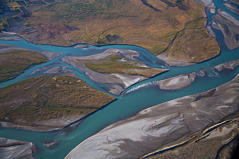
File:Kabul_River_flood-plain_east_of_Kabul,_Afghanistan.jpg · Wikimedia Commons · See Wikimedia Commons
The Kabul River is a major waterway that flows through Afghanistan and Pakistan, serving as an important water source for the regions it passes through. It matters because it provides water for agriculture, drinking, and other essential uses for the millions of people living along its banks in both countries.
AI-generated from the Wikipedia summary — may contain errors.
Wikidata facts
- Instance of
- river
- Country
- Pakistan
- Located in
- Khyber Pakhtunkhwa
- Image
- Kabul River in Kabul 2005-12-05 MG 2110.jpg
- Length
- 460
Show 6 more facts
- mouth of the watercourse
- Indus River
- Commons category
- Kabul River
- tributary
- Bara River
- watershed area
- 75000
- topic's main category
- Category:Kabul River
- described by source
- Pauly–Wissowa
Sources (2)
via Wikidata · CC0
~5 min read
Encyclopedic overview
The Kabul River is a 700-kilometre-long (430 mi) river that emerges in the Sanglakh Range of the Hindu Kush mountains in the northeastern part of Maidan Wardak Province, Afghanistan. It is separated from the watershed of the Helmand River by the Unai Pass. The Kabul River empties into the Indus River near Attock, Pakistan. It is the major river in eastern Afghanistan and the Khyber Pakhtunkhwa province of Pakistan.
Names
Excerpted from Wikipedia’s “Kabul River” article, available under the CC BY-SA 4.0 licence.
Gallery (6)
On the map
2 mapped locations
Available in 62 languages
- Español
- Français
- Deutsch
- 中文
- 日本語
- Русский
- Português
- Italiano
- العربية
- हिन्दी
- Armenian
- azb
- Bahasa Indonesia
- Bangla
- Basque
- Belarusian
- Bulgarian
- Catalan
Show 43 more
- Cebuano
- Chuvash
- Czech
- Egyptian Arabic
- Esperanto
- Estonian
- Finnish
- Galician
- Greek
- Gujarati
- Hungarian
- Latvian
- Lithuanian
- Malayalam
- Marathi
- Mongolian
- Nederlands
- Norwegian
- Norwegian Nynorsk
- Pashto
- Polski
- Punjabi
- Romanian
- Serbian
- simple
- Sindhi
- Slovak
- Slovenian
- Svenska
- Tajik
- Tamil
- Telugu
- Tiếng Việt
- Türkçe
- Ukrainian
- Urdu
- Uzbek
- Welsh
- Western Panjabi
- Wu Chinese
- فارسی
- ไทย
- 한국어
via Wikidata sitelinks · CC0