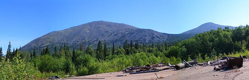
File:Yamantau.JPG · Wikimedia Commons · See Wikimedia Commons
Mount Yamantau
Sign in to saveAlso known as Mount Yamantaw, Gora Yamantau
mountain in the Ural Mountains, Bashkortostan, Russia
Key facts
- Elevation
- 1,640 m (5,380 ft)
- Listing
- Mountains of Russia
- Coordinates
- 54°15′18″N 58°06′13″E / 54.255°N 58.10365°E / 54.255; 58.10365
- Country
- Russia
- Republic
- Bashkortostan
- District
- Beloretsky
- Protected area
- South Ural Nature Reserve
- Parent range
- Ural Mountains
via Wikipedia infobox
Described at
Yamantau
globalsecurity.org →Get the top defense news stories delivered to you every morning, six days a week! We value your privacy. We will not rent or sell your email address. SENSE OF CONGRESS ON NEED FOR RUSSIAN OPENNESS ON THE YAMANTAU MOUNTAIN PROJECT (House of Representatives - June 19, 1997) Moscow builds bunkers against nuclear attack By Bill Gertz THE WASHINGTON TIMES 01 April 1997 pg 1 General Denies Nuclear Construction in Urals , INTERFAX, 4/18/1996 -- The commander of Russia's missile forces has denied allegations that an underground anti-nuclear bunker is under construction outside the city of Beloretsk in Bashkortostan near the Yamantau Mountain. What Is That There Under the Mountain? , A. Urtsev and V. Yeldashev, BELORETSKIY RABOCHIY, 3/24/1996 -- Interview with Bashkortostan People's Deputy Leonid Akimovich Tsirkunov outlining the purpose of the facilities that are being built in the cities of Beloretsk-15 and Beloretsk-16. Inzer Isn't All That Bad , L. Tsirkunov, BELORETSKIY RABOCHIY, 9/2/1993 -- Further on Pollution at Beloretsk-15 Returning to What Was Printed: Don't Drink Water From the Inzer! , G. Sitdikova, BELORETSKIY RABOCHIY, 8/7/1993 -- Biological Clean-Up Work At Beloretsk-15 Natural Landmarks of Beloretsk Rayon , A. Dmitriyev, BELORETSKIY RABOCHIY, 7/22/1993 -- Geographical features of a polluted region. One of the Secrets of Yaman- Tau , A. Vorobyev, BELORETSKIY RABOCHIY, 7/13/1991 -- Essay on a 1975 reconnaissance plane crash in the Bashkortostan region in Russia. Contradiction of Yamantau's Status as Preserve and Facility Questioned , 7/2/1991 -- Expresses support for protecting the polluted Bashkortostan region. U.S. Officials Puzzled By Big Hole Russians Are Digging By Terry Atlas, Chicago Tribune April 17, 1996 Mount Weather's Russian Twin By Patricia Neill Matrix Editor MT. YAMANTAU -- FROM THE FOLKS WHO BROUGHT YOU THE COLD WAR DECISION BRIEF No. 96-D 37 - 16 April 1996 WHY IS RUSSIA PREPARING FOR WAR? The exact location of this large facility is uncertain, and given its reported size it may span as much as an entire degree of latitude and longitude. It is apparently located near the the Zlatoust-36/Yuryuzan nuclear weapons production plant and the Yuryuzan national-level nuclear weapons storage facility. The Yaman-Tau Gory [mountains] range is centered at 52�25'N 56�45'E, while the peak of Yamantau Gora [mountain] is at 54�15'19"N 58�06'11"E. The town of Beloretsk is located at 53�58'N 58�24'E, though NIMA does not include a listing for Mezhgorye. This facility may be synonymous with "Alkino-2" since the town of Al'kino is nearby at 55�05'N 58�04'E. On April 16, 1996, the New York Times reported on a mysterious military base being constructed in Russia: "In a secret project reminiscent of the chilliest days of the Cold War, Russia is building a mammoth underground military complex in the Ural Mountains, Western officials and Russian witnesses say. Hidden inside Yamantau mountain in the Beloretsk area of the southern Urals, the project involved the creation of a huge complex, served by a railroad, a highway, and thousands of workers." The New York Times quoted Russian officials describing the underground compound variously as a mining site, a repository for Russian treasures, a food storage area, and a bunker for Russia's leaders in case of nuclear war. "The (Russian) Defense Ministry declined to say whether Parliament has been informed about the details of the project, like its purpose and cost, saying only that it receives necessary military information," according to the New York Times. Satellite photographs of Yamantau Mountain show continued digging at the "deep undergound complex" and new construction at each of the site's above-ground support areas. Judging from satellite photos and other intelligence, US officials are fairly confident that the Russians are building an underground command bunker and communications installation. But "... the Russians are not very interested in having us go in there," a s
Excerpt from a page describing this subject · 14,373 chars · not written by Vinony
Wikidata facts
- Instance of
- mountain
- Part of
- Southern Ural
- Country
- Soviet Union
- Located in
- Bashkortostan
- Elevation
- 1640
- Operator
- Russian Armed Forces
- Image
- Yamantau.JPG
Show 6 more facts
- Commons category
- Yamantau
- mountain range
- Ural Mountains
- inception
- 2003-00-00
- topographic prominence
- 1330
- described at URL
- www.globalsecurity.org/wmd/world/russia/yamantau.htm
- has facility
- bunker
Sources (2)
via Wikidata · CC0
~3 min read
Encyclopedic overview
Mount Yamantau, or Yamantaw (Russian: гора Ямантау, Bashkir: Ямантау, romanized: Yamantaw) is a mountain in the Ural Mountains, located in Beloretsky District, Bashkortostan, Russia. Standing at 1,640 metres (5,380 ft), it is the highest mountain in the Southern Ural section, and lies within the South Ural Nature Reserve.
An extensive secret bunker complex has allegedly been built under Yamantau, per United States claims, by the Russian government or the Russian Armed Forces, similar to the Cheyenne Mountain Complex in the U.S. state of Colorado.
Excerpted from Wikipedia’s “Mount Yamantau” article, available under the CC BY-SA 4.0 licence.
On the map
2 mapped locations