File:Turkish_Strait_disambig.svg · Wikimedia Commons · See Wikimedia Commons
Bosporus Strait
Sign in to saveAlso known as Bosphorus, Istanbul Strait, Thracian Bosporus, Bosporus Thracian, Strait of Istanbul
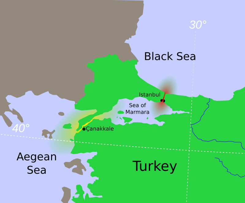
thumb|Location of the Bosporus (red) relative to the Dardanelles (yellow) and the [[Sea of Marmara]] thumb|Close-up satellite image of the Bosporus Strait, taken from the International Space Station in April 2004. The body of water at the top is the [[Black Sea, the one at the bottom is the Marmara Sea, and the Bosporus is the winding waterway that connects the two. The western banks of the Bosporus constitute the geographic starting point of the European continent, while the banks to the east are the geographic beginnings of the continent of Asia. The city of Istanbul is visible along both ba
The Bosporus Strait is a narrow waterway that connects the Black Sea to the Sea of Marmara, with Istanbul situated on its banks and the strait marking the geographic boundary between Europe and Asia. It matters because it serves as a crucial passageway for maritime traffic between these two regions and between the continents.
AI-generated from the Wikipedia summary — may contain errors.
Key facts
- Body of water.name
- Bosporus Strait
- Body of water.basin_countries
- Turkey
- Body of water.pushpin_map
- Istanbul#Turkey#Europe#Asia
- Body of water.part_of
- Turkish Straits
- Body of water.type
- Strait
via Wikipedia infobox
Wikidata facts
- Instance of
- strait
- Part of
- Sea of Marmara
- Country
- Turkey
- Located in
- Istanbul Province
- Continent
- Europe
- Image
- Istanbul and Bosporus big.jpg
- Length
- 29.9
Show 8 more facts
- native label
- İstanbul Boğazı
- Commons category
- Bosphorus
- topic's main category
- Category:Bosphorus
- Commons gallery
- Bosphorus
- vertical depth
- 186
- heritage designation
- Important Bird Area
- different from
- Bosporan Kingdom
- on focus list of Wikimedia project
- Wikipedia:Vital articles/Level/4
Sources (6)
via Wikidata · CC0
~31 min read
Encyclopedic overview
26 sectionsContents
- Name
- Boğaziçi
- Geography
- Formation
- Present morphology
- Newer explorations
- Villages
- Human history
- Ancient Greek, Persian, Roman and Byzantine eras (pre-1453)
- Ottoman era (1453–1922)
- Summer Embassies
- Turkish republican era (1923–present)
- Istanbul Canal
- In mythology
- Crossings
- Maritime
- Land bridges
- Submarine
- Strategic importance
- Sightseeing
- Architecture
- Egyptian legacy
- See also
- References
- Sources
- External links
thumb|Location of the Bosporus (red) relative to the Dardanelles (yellow) and the [[Sea of Marmara]] thumb|Close-up satellite image of the Bosporus Strait, taken from the International Space Station in April 2004. The body of water at the top is the [[Black Sea, the one at the bottom is the Marmara Sea, and the Bosporus is the winding waterway that connects the two. The western banks of the Bosporus constitute the geographic starting point of the European continent, while the banks to the east are the geographic beginnings of the continent of Asia. The city of Istanbul is visible along both banks.]] thumb|Aerial view of the Bosporus taken from its northern end near the Black Sea (bottom), looking south (top) toward the Marmara Sea, with the city center of Istanbul visible along the strait's hilly banks
The Bosporus or Bosphorus Strait is a natural strait and an internationally significant waterway located in Turkey which is straddled by the city of Istanbul. The Bosporus connects the Black Sea to the Sea of Marmara and forms one of the continental boundaries between Asia and Europe. It also divides Turkey by separating Asia Minor from Thrace. It is the world's narrowest strait used for international navigation.
Excerpted from Wikipedia’s “Bosporus Strait” article, available under the CC BY-SA 4.0 licence.
Gallery (539)
On the map
31 mapped locations
Available in 120 languages
- Español
- Français
- Deutsch
- 中文
- 日本語
- Русский
- Português
- Italiano
- العربية
- हिन्दी
- Afrikaans
- Albanian
- Amharic
- Aragonese
- Armenian
- Asturian
- azb
- Azerbaijani
Show 101 more
- Bahasa Indonesia
- Bangla
- Bashkir
- Basque
- be_x_old
- Belarusian
- Bosnian
- Breton
- Bulgarian
- Buriat
- Catalan
- Cebuano
- Central Kurdish
- Chechen
- Chuvash
- Croatian
- Czech
- Danish
- Egyptian Arabic
- Esperanto
- Estonian
- Extremaduran
- Finnish
- Gagauz
- Galician
- Georgian
- Greek
- Guarani
- Hebrew
- Hungarian
- Icelandic
- Ido
- Interlingua
- Interlingue
- Irish
- Javanese
- Kara-Kalpak
- Kazakh
- Kurdish
- Kyrgyz
- Ladino
- Latin
- Latvian
- Limburgish
- Lithuanian
- Lombard
- Low German
- Luxembourgish
- Macedonian
- Malay
- Malayalam
- Marathi
- Mazanderani
- Mingrelian
- Mongolian
- Nederlands
- Newari
- Northern Frisian
- Norwegian
- Norwegian Nynorsk
- Occitan
- Old English
- Ossetic
- Pashto
- Polski
- Romanian
- Rusyn
- Sardinian
- Scottish Gaelic
- Serbian
- Serbian (Latin)
- Sicilian
- simple
- skr
- Slovak
- Slovenian
- Somali
- Sundanese
- Svenska
- Swahili
- Tajik
- Tamil
- Tatar
- Tiếng Việt
- Türkçe
- Ukrainian
- Upper Sorbian
- Urdu
- Uzbek
- Walloon
- Waray
- Welsh
- West Flemish
- Western Frisian
- Western Panjabi
- Wu Chinese
- Yiddish
- zh_yue
- فارسی
- ไทย
- 한국어
via Wikidata sitelinks · CC0