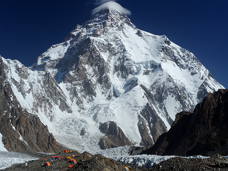
File:Chogori.jpg · Wikimedia Commons · See Wikimedia Commons
Also known as Mount Godwin-Austen, Chhogori, Mount K2, Dapsang, Mt. Qogir
Berg im Karakorum
K2, also known as Mount Godwin-Austen, is the second-highest mountain on Earth after Mount Everest, located in the Karakoram range on the border between Pakistan-administered Kashmir and China-administered Xinjiang. It matters as one of the world's most significant peaks and a major landmark in a geographically and geopolitically important region.
AI-generated from the Wikipedia summary — may contain errors.
Key facts
- Mountain.fetchwikidata
- ALL
- Mountain.name
- K2
- Mountain.elevation_m
- 8611
- Mountain.parent
- Karakoram
- Mountain.map
- China Xinjiang Southern#Gilgit Baltistan
- Mountain.map_caption
- Location of K2 relative to Xinjiang and Gilgit−Baltistan
- Mountain.label_position
- right
- Mountain.country
- Pakistan-administered Kashmir China-administered Trans-Karakoram Tract
- Mountain.first_ascent
- Achille Compagnoni & Lino Lacedelli Nepalese team (winter)
- Mountain.easiest_route
- Abruzzi Spur
- Mountain.mapframe
- no
- Mountain.listing
- Eight-thousanderSeven Second SummitsUltra
- Mountain.etymology
- Second peak measured in the Karakoram Range by the Survey of India, hence "K2" "Mount Godwin-Austen" derives from Henry Godwin-Austen, who first surveyed the peak
via Wikipedia infobox
Wikidata facts
- Instance of
- mountain
- Part of
- ultra-prominent peak
- Named after
- Henry Haversham Godwin-Austen
- Country
- Pakistan
- Located in
- Taxkorgan Tajik Autonomous County
- Elevation
- 8611
- Image
- K - 2 at Day Time.jpg
Show 10 more facts
- category for people who died here
- Category:Deaths on K2
- peak bagging classification
- eight-thousander
- topographic prominence
- 4020
- topographic isolation
- 1316
- Commons gallery
- K2
- mountain range
- Baltoro Muztagh
- Commons category
- K2
- topic's main category
- Category:K2
- described by source
- Encyclopædia Britannica 11th edition
- on focus list of Wikimedia project
- Wikipedia:Vital articles/Level/4
via Wikidata · CC0
Article · Deutsch
Der K2 (in China offiziell: Qogir, chinesisch 乔戈里峰, Pinyin Qiáogēlǐ Fēng) ist mit 8611 m der höchste Berg im Karakorum und nach dem Mount Everest der zweithöchste Berg der Erde. Der K2 gilt unter Bergsteigern als weit anspruchsvoller als der Mount Everest, wenn nicht sogar als der schwierigste aller vierzehn Achttausender. Gründe dafür sind die durchgehend steile Route, die höhere Lawinengefahr und schlechte Rückzugsmöglichkeiten bei Wetterwechseln. Als zweithöchster Berg Asiens zählt er zu den Seven Second Summits.
Abstract from DBpedia / Wikipedia · CC BY-SA
Gallery (33)
On the map
59 mapped locations
Available in 107 languages
- Español
- Français
- Deutsch
- 中文
- 日本語
- Русский
- Português
- Italiano
- العربية
- हिन्दी
- Afrikaans
- Albanian
- Aragonese
- Armenian
- Asturian
- Azerbaijani
- Bahasa Indonesia
- Bangla
Show 88 more
- Bashkir
- Basque
- bat_smg
- be_x_old
- Belarusian
- Bhojpuri
- Bosnian
- Breton
- Bulgarian
- Catalan
- Cebuano
- Cornish
- Croatian
- Czech
- Danish
- Egyptian Arabic
- Esperanto
- Estonian
- Filipino
- Finnish
- Galician
- Georgian
- Greek
- Hebrew
- Hungarian
- Icelandic
- Ido
- Irish
- Javanese
- Kannada
- Kazakh
- Kurdish
- Kyrgyz
- Lao
- Latin
- Latvian
- Lithuanian
- lld
- Macedonian
- Maithili
- Malay
- Malayalam
- Marathi
- Mingrelian
- Nederlands
- Nepali
- Norwegian
- Norwegian Nynorsk
- Occitan
- Pashto
- Polski
- Punjabi
- Romanian
- Romansh
- Scots
- Serbian
- Serbian (Latin)
- simple
- Sindhi
- skr
- Slovak
- Slovenian
- Somali
- Sundanese
- Svenska
- Swahili
- Tajik
- Tamil
- Telugu
- Tiếng Việt
- Toki Pona
- Tulu
- Türkçe
- Ukrainian
- Urdu
- Uyghur
- Uzbek
- Venetian
- Waray
- Welsh
- Western Frisian
- Western Panjabi
- Wu Chinese
- zh_min_nan
- zh_yue
- فارسی
- ไทย
- 한국어
via Wikidata sitelinks · CC0