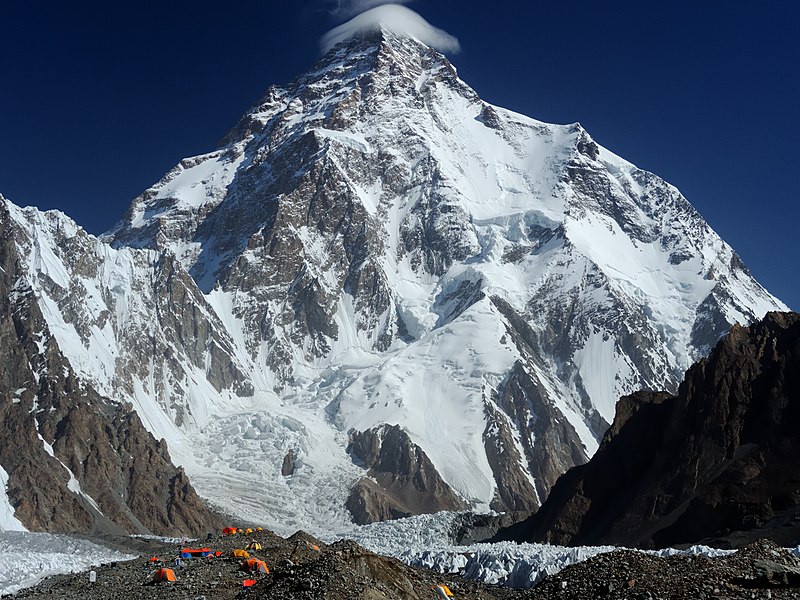
File:Chogori.jpg · Wikimedia Commons · See Wikimedia Commons
Also known as Mount Godwin-Austen, Chhogori, Mount K2, Dapsang, Mt. Qogir
montagne pakistanaise
K2, also known as Mount Godwin-Austen, is the second-highest mountain on Earth after Mount Everest, located in the Karakoram range on the border between Pakistan-administered Kashmir and China-administered Xinjiang. It matters as one of the world's most significant peaks and a major landmark in a geographically and geopolitically important region.
AI-generated from the Wikipedia summary — may contain errors.
Key facts
- Mountain.fetchwikidata
- ALL
- Mountain.name
- K2
- Mountain.elevation_m
- 8611
- Mountain.parent
- Karakoram
- Mountain.map
- China Xinjiang Southern#Gilgit Baltistan
- Mountain.map_caption
- Location of K2 relative to Xinjiang and Gilgit−Baltistan
- Mountain.label_position
- right
- Mountain.country
- Pakistan-administered Kashmir China-administered Trans-Karakoram Tract
- Mountain.first_ascent
- Achille Compagnoni & Lino Lacedelli Nepalese team (winter)
- Mountain.easiest_route
- Abruzzi Spur
- Mountain.mapframe
- no
- Mountain.listing
- Eight-thousanderSeven Second SummitsUltra
- Mountain.etymology
- Second peak measured in the Karakoram Range by the Survey of India, hence "K2" "Mount Godwin-Austen" derives from Henry Godwin-Austen, who first surveyed the peak
via Wikipedia infobox
Wikidata facts
- Instance of
- mountain
- Part of
- ultra-prominent peak
- Named after
- Henry Haversham Godwin-Austen
- Country
- Pakistan
- Located in
- Taxkorgan Tajik Autonomous County
- Elevation
- 8611
- Image
- K - 2 at Day Time.jpg
Show 10 more facts
- category for people who died here
- Category:Deaths on K2
- peak bagging classification
- eight-thousander
- topographic prominence
- 4020
- topographic isolation
- 1316
- Commons gallery
- K2
- mountain range
- Baltoro Muztagh
- Commons category
- K2
- topic's main category
- Category:K2
- described by source
- Encyclopædia Britannica 11th edition
- on focus list of Wikimedia project
- Wikipedia:Vital articles/Level/4
via Wikidata · CC0
Article · Français
Le K2 (aussi connu sous les noms de Qogir Feng, Chogori, Ketu/Kechu et historiquement mont Godwin-Austen) est un sommet du massif du Karakoram ou Karakorum (d'où la lettre K utilisée pour le désigner), qui est situé sur la frontière sino-pakistanaise dans la région autonome du Gilgit-Baltistan (district de Skardu). Avec une altitude officielle de 8 611 m, c'est le deuxième sommet du monde après l'Everest. Il est surnommé « montagne Sauvage » en raison de la difficulté de son ascension, ou « montagne sans pitié ». Sa première ascension est réussie en 1954 par Achille Compagnoni et Lino Lacedelli et la première hivernale est réussie en 2021 par une équipe népalaise menée par Nirmal Purja et . Les pentes du K2 et le camp de base de la voie normale ont été nettoyés par une équipe de Mountain Wilderness en 1990, opération ayant mis en évidence la dégradation des sites les plus reculés de l'Himalaya par une trop importante fréquentation d'alpinistes en très grande majorité étrangers.
Abstract from DBpedia / Wikipedia · CC BY-SA
Gallery (33)
On the map
59 mapped locations
Available in 107 languages
- Español
- Français
- Deutsch
- 中文
- 日本語
- Русский
- Português
- Italiano
- العربية
- हिन्दी
- Afrikaans
- Albanian
- Aragonese
- Armenian
- Asturian
- Azerbaijani
- Bahasa Indonesia
- Bangla
Show 88 more
- Bashkir
- Basque
- bat_smg
- be_x_old
- Belarusian
- Bhojpuri
- Bosnian
- Breton
- Bulgarian
- Catalan
- Cebuano
- Cornish
- Croatian
- Czech
- Danish
- Egyptian Arabic
- Esperanto
- Estonian
- Filipino
- Finnish
- Galician
- Georgian
- Greek
- Hebrew
- Hungarian
- Icelandic
- Ido
- Irish
- Javanese
- Kannada
- Kazakh
- Kurdish
- Kyrgyz
- Lao
- Latin
- Latvian
- Lithuanian
- lld
- Macedonian
- Maithili
- Malay
- Malayalam
- Marathi
- Mingrelian
- Nederlands
- Nepali
- Norwegian
- Norwegian Nynorsk
- Occitan
- Pashto
- Polski
- Punjabi
- Romanian
- Romansh
- Scots
- Serbian
- Serbian (Latin)
- simple
- Sindhi
- skr
- Slovak
- Slovenian
- Somali
- Sundanese
- Svenska
- Swahili
- Tajik
- Tamil
- Telugu
- Tiếng Việt
- Toki Pona
- Tulu
- Türkçe
- Ukrainian
- Urdu
- Uyghur
- Uzbek
- Venetian
- Waray
- Welsh
- Western Frisian
- Western Panjabi
- Wu Chinese
- zh_min_nan
- zh_yue
- فارسی
- ไทย
- 한국어
via Wikidata sitelinks · CC0