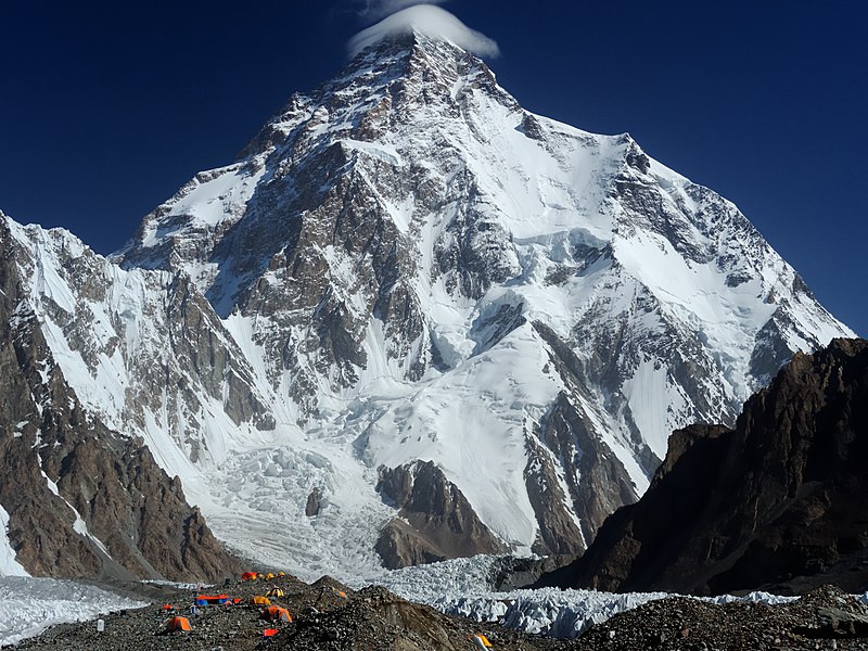
File:Chogori.jpg · Wikimedia Commons · See Wikimedia Commons
Also known as Mount Godwin-Austen, Chhogori, Mount K2, Dapsang, Mt. Qogir
seconda montagna più alta della Terra
K2, also known as Mount Godwin-Austen, is the second-highest mountain on Earth after Mount Everest, located in the Karakoram range on the border between Pakistan-administered Kashmir and China-administered Xinjiang. It matters as one of the world's most significant peaks and a major landmark in a geographically and geopolitically important region.
AI-generated from the Wikipedia summary — may contain errors.
Key facts
- Mountain.fetchwikidata
- ALL
- Mountain.name
- K2
- Mountain.elevation_m
- 8611
- Mountain.parent
- Karakoram
- Mountain.map
- China Xinjiang Southern#Gilgit Baltistan
- Mountain.map_caption
- Location of K2 relative to Xinjiang and Gilgit−Baltistan
- Mountain.label_position
- right
- Mountain.country
- Pakistan-administered Kashmir China-administered Trans-Karakoram Tract
- Mountain.first_ascent
- Achille Compagnoni & Lino Lacedelli Nepalese team (winter)
- Mountain.easiest_route
- Abruzzi Spur
- Mountain.mapframe
- no
- Mountain.listing
- Eight-thousanderSeven Second SummitsUltra
- Mountain.etymology
- Second peak measured in the Karakoram Range by the Survey of India, hence "K2" "Mount Godwin-Austen" derives from Henry Godwin-Austen, who first surveyed the peak
via Wikipedia infobox
Wikidata facts
- Instance of
- mountain
- Part of
- ultra-prominent peak
- Named after
- Henry Haversham Godwin-Austen
- Country
- Pakistan
- Located in
- Taxkorgan Tajik Autonomous County
- Elevation
- 8611
- Image
- K - 2 at Day Time.jpg
Show 10 more facts
- category for people who died here
- Category:Deaths on K2
- peak bagging classification
- eight-thousander
- topographic prominence
- 4020
- topographic isolation
- 1316
- Commons gallery
- K2
- mountain range
- Baltoro Muztagh
- Commons category
- K2
- topic's main category
- Category:K2
- described by source
- Encyclopædia Britannica 11th edition
- on focus list of Wikimedia project
- Wikipedia:Vital articles/Level/4
via Wikidata · CC0
Article · Italiano
Il K2 (pron. /kappaˈdue/), abbreviazione di Karakorum 2, conosciuto anche come Monte Godwin-Austen, ChogoRi (lingua balti) o Dapsang, è con i suoi 8 609 metri di altitudine s.l.m. la seconda vetta più alta della Terra dopo l'Everest, situato nella subcatena del Karakorum, al confine tra la parte del Kashmir controllata dal Pakistan e la Provincia Autonoma Tagica di Tashkurgan di Xinjiang, Cina.
Abstract from DBpedia / Wikipedia · CC BY-SA
Gallery (33)
On the map
59 mapped locations
Available in 107 languages
- Español
- Français
- Deutsch
- 中文
- 日本語
- Русский
- Português
- Italiano
- العربية
- हिन्दी
- Afrikaans
- Albanian
- Aragonese
- Armenian
- Asturian
- Azerbaijani
- Bahasa Indonesia
- Bangla
Show 88 more
- Bashkir
- Basque
- bat_smg
- be_x_old
- Belarusian
- Bhojpuri
- Bosnian
- Breton
- Bulgarian
- Catalan
- Cebuano
- Cornish
- Croatian
- Czech
- Danish
- Egyptian Arabic
- Esperanto
- Estonian
- Filipino
- Finnish
- Galician
- Georgian
- Greek
- Hebrew
- Hungarian
- Icelandic
- Ido
- Irish
- Javanese
- Kannada
- Kazakh
- Kurdish
- Kyrgyz
- Lao
- Latin
- Latvian
- Lithuanian
- lld
- Macedonian
- Maithili
- Malay
- Malayalam
- Marathi
- Mingrelian
- Nederlands
- Nepali
- Norwegian
- Norwegian Nynorsk
- Occitan
- Pashto
- Polski
- Punjabi
- Romanian
- Romansh
- Scots
- Serbian
- Serbian (Latin)
- simple
- Sindhi
- skr
- Slovak
- Slovenian
- Somali
- Sundanese
- Svenska
- Swahili
- Tajik
- Tamil
- Telugu
- Tiếng Việt
- Toki Pona
- Tulu
- Türkçe
- Ukrainian
- Urdu
- Uyghur
- Uzbek
- Venetian
- Waray
- Welsh
- Western Frisian
- Western Panjabi
- Wu Chinese
- zh_min_nan
- zh_yue
- فارسی
- ไทย
- 한국어
via Wikidata sitelinks · CC0