File:Kingdoms_around_Israel_830_map.svg · Wikimedia Commons · See Wikimedia Commons
Also known as Moabite
Moab () was an ancient Levantine kingdom whose territory is today located in southern Jordan. The land is mountainous and lies alongside much of the eastern shore of the Dead Sea. The existence of the Kingdom of Moab is attested to by numerous archaeological findings, most notably the Mesha Stele, which describes the Moabite victory over an unnamed son of King Omri of Israel, an episode also noted in 2 Kings 3. The Moabite capital was Dibon. According to the Hebrew Bible, Moab was often in conflict with its Israelite neighbours to the west.
Moab was an ancient kingdom located in what is now southern Jordan, east of the Dead Sea, whose existence is confirmed by archaeological evidence including the famous Mesha Stele. It matters historically because it provides insight into the ancient Levantine world and its interactions with neighboring kingdoms like Israel, as documented in both archaeological records and biblical texts.
AI-generated from the Wikipedia summary — may contain errors.
In the Vinony graph
Within Vinony's link graph, モアブ is referenced by 882 other articles, and connects out to Jordan, Bronze Age and David.
The entry is geolocated on the map, across 3 mapped points.
It is catalogued under topics including Ancient peoples of the Near East, Book of Amos locations and Book of Deuteronomy locations.
Its subject is documented across 55 Wikipedia language editions.
Key facts
- Country.religion
- Canaanite religion
- Country.native_name
- 𐤌𐤀𐤁
- Country.conventional_long_name
- Kingdom of Moab
- Country.common_name
- Moab
- Country.capital
- Dibon
- Country.common_languages
- Moabite
- Country.status
- Monarchy
- Country.year_start
- c. 13th century BCE
- Country.event_end
- Collapsed
- Country.year_end
- c. 400 BCE
- Country.image_map
- Kingdoms around Israel 830 map.svg
- Country.image_map_caption
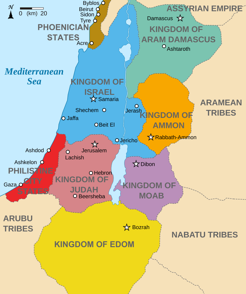
- A theoretical map of Canaan around 830 BCE. Moab is shown in purple on this map, between the Arnon and Zered rivers.
- Country.today
- Jordan, Israel
via Wikipedia infobox
Wikidata facts
Show 7 more facts
- Commons category
- Moab
- topic's main category
- Category:Moab
- different from
- Moab
- language used
- Moabite
- dissolved, abolished or demolished date
- 0400-00-00
- inception
- 1300-00-00
- native label
- מוֹאָב
via Wikidata · CC0
Article · 日本語
モアブ(:𐤌𐤀𐤁)は、古代イスラエルの東に隣接した地域の古代の地名であり、死海の東岸、アルノン川(現ヨルダン・ハシミテ王国のワディ・アル・ムジブ)以南からゼレド川以北(現ヨルダンのワディ・アル・ハサ)の高原地帯に広がる地域を指す。この地域は、現在のヨルダン・ハシミテ王国のカラク高原地域(カラク県)にほぼ等しい。なおモアブと呼ばれた地域は、中世イスラム期にはマアブ(Maāb)と呼ばれていたことが、9世紀のアラブ人地理学者ヤアクービーの記述から分かる。 旧約聖書によれば、ロトとロトの長女との間に生まれた息子モアブ(מואב ヘブライ語で「父によって」の意)に由来し、その子孫がモアブ人となってを打ち払ってその地域に定住したとされている。
Abstract from DBpedia / Wikipedia · CC BY-SA
Gallery (14)
On the map
3 mapped locations