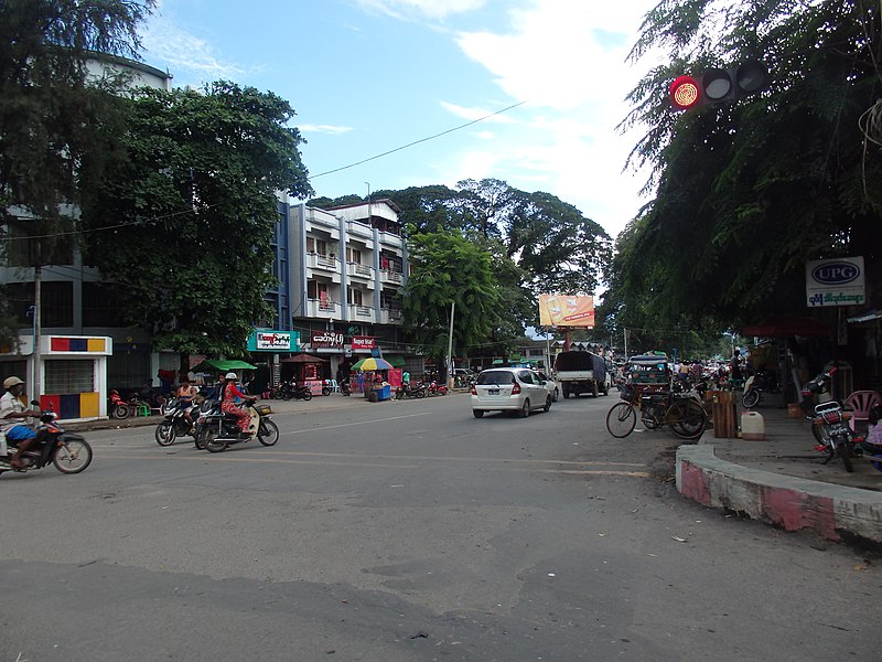
File:Myitkyina,_Myanmar_(Burma)_-_panoramio_(1).jpg · Wikimedia Commons · See Wikimedia Commons
Myitkyina
Sign in to saveMyitkyina (, ; Jinghpaw: Myitkyina, ; ) is the capital city of Kachin State in Myanmar (Burma), located from Yangon, and from Mandalay. In Burmese it means "near the big river", and Myitkyina is on the west bank of the Ayeyarwady River, just downstream from Myit-son (Burmese for confluence) of its two headstreams (the Mali and N'mai rivers). It is the northernmost river port and railway terminus in Myanmar. The city is served by Myitkyina Airport.
OverviewAI-generated
Myitkyina is a city in Myanmar and serves as the capital of Kachin State. Located within Myitkyina Township, the city sits at an elevation of approximately 144 to 147 meters above sea level. It operates in the Asia/Yangon time zone, which corresponds to UTC+06:30. The local dialing code for the area is 74.
Population figures for Myitkyina vary by source, with estimates ranging from 90,894 to 243,031 residents. The city is the site of the historical Siege of Myitkyina and has been described in the Encyclopædia Britannica 11th edition. Current weather data indicates a temperature of 22.48 degrees Celsius with 99% humidity.
Synthesized by Vinony from 44 facts across 7 sources: Wikidata, Open Meteo, Openweathermap, OpenStreetMap, GeoNames, Vinony graph, Geo. Generated from structured data (not the Wikipedia text) and checked against those facts — may still contain errors.
Weather now
7-day forecast
via Open-Meteo
Place details
- Locality
- မြစ်ကြီးနားမြို့
- Region
- ကချင်ပြည်နယ်
- Country
- မြန်မာ
- Population
- 90,894
- Timezone
- Asia/Yangon
via OpenStreetMap · GeoNames
Key facts
- Settlement.settlement_type
- Capital Town
- Settlement.native_name
- မြစ်ကြီးနားမြို့
- Settlement.native_name_lang
- my
- Settlement.official_name
- Myitkyina
- Settlement.pushpin_label_position
- bottom
- Settlement.pushpin_map
- Myanmar
- Settlement.pushpin_map_caption
- Location in Myanmar (Burma)
- Settlement.image_skyline
- Myitkyina, Myanmar (Burma) - panoramio (1).jpg
- Settlement.imagesize
- 300px
- Settlement.subdivision_type
- Country
- Settlement.subdivision_type1
- Division
- Settlement.subdivision_type2
- District
- Settlement.subdivision_name2
- Myitkyina District
- Settlement.subdivision_type3
- Township
- Settlement.subdivision_name3
- Myitkyina Township
- Settlement.unit_pref
- Imperial
- Settlement.area_code
- 74
- Settlement.population_as_of
- 2014
via Wikipedia infobox
Wikidata facts
- Country
- Myanmar
- Located in
- British rule in Myanmar
- Population
- 243031
- Elevation
- 144
- Time zone
- UTC+06:30
- Capital of
- Kachin State
- Image
- Myitkyina-ayeyarwady-d01.jpg
- Dialing code
- 74
- Significant event
- Siege of Myitkyina
Show 4 more facts
- Commons category
- Myitkyina
- topic's main category
- Category:Myitkyina
- described by source
- Encyclopædia Britannica 11th edition
via Wikidata · CC0
Travel guide
Understand
Although today a sleepy backwater, Myitkyina was the site of a bitter battle between Japanese and Allied forces during the Second World War. The town was almost completely destroyed in the battle. The location of the town, in an opportunistic valley between India and China, made it strategic enough to be on the Ledo Road built by the US General Joseph Stilwell. Myitkyina could, one day, become an important way station for trade between the two Asian giants, India and China. For now, Myitkyina is a destination because of the journey. There is no road or river connection to Bhamo due to conflicts between "rebels" and the army south of the city) and because it is a staging point for trips to Indawgyi Lake and Putao (Jun 2012).
The best time to visit is in late Oct-early Feb.
Get around
Myitkyina is small. You can get anywhere in the city by trishaw or by walking.
If you arrive by train, turn left and walk along the main street to get to the city centre. After reaching an intersection with a clock tower, turn right and left to go to New Light Hotel, or left and right for the YMCA.
As of February 2018 foreigners are still barred from river or overland travel to Bhamo To reach Bhamo there is only one flight a week, Myanmar Air leaving at 1 pm Monday's. The flight is only 25 minutes and as of February 2018 the cost was $86 USD with taxes and travel agent fees. Other option is to travel to Katha and travel up river by boat.
Tuk tuk to the airport (10 minutes from the city) will be around 3,000-4,000 kyat.
Do
Visit the memorial dedicated to the Chinese Expeditionary Forces.
Buy
One can find and buy the world's best jade and gems. Buy Kachin traditional dresses, handicrafts, and other national cultural textiles and food.
Go next
Myitson (Mali Zup in Kachin language), the confluence of Mali and Nmai Rivers and the starting point of the Irrawady River, 32 km from Myitkyina Indawgyi Lake
Travel guide from Wikivoyage (CC BY-SA 4.0)
~6 min read
Encyclopedic overview
14 sectionsContents
- History
- Climate
- Air quality
- Population
- Religion
- Economy
- Transportation
- Education
- Healthcare
- Public hospitals
- Military
- See also
- Notes
- External links
Myitkyina (, ; Jinghpaw: Myitkyina, ; ) is the capital city of Kachin State in Myanmar (Burma), located from Yangon, and from Mandalay. In Burmese it means "near the big river", and Myitkyina is on the west bank of the Ayeyarwady River, just downstream from Myit-son (Burmese for confluence) of its two headstreams (the Mali and N'mai rivers). It is the northernmost river port and railway terminus in Myanmar. The city is served by Myitkyina Airport.
==History== The area surrounding Myitkyina, including what is now Waingmaw, has been an important trading zone between China and Myanmar since ancient times. The nearby town of Katkyo, from the Shan Kat Kio (), had its legendary founding in 1294 on the left (east) bank of the river. The region was then under the rule of Möng Kawng and other Shan states until the Konbaung dynasty, when it increasingly came under the control of Burmese and Kachin authorities.
Excerpted from Wikipedia’s “Myitkyina” article, available under the CC BY-SA 4.0 licence.
Gallery (10)
On the map
6 mapped locations