
File:Roraima3_(79).JPG · Wikimedia Commons · See Wikimedia Commons
Mount Roraima
Also known as Roraima Tepui, Pico do Roraima, Mt. Roraima, Cerro Roraima, Roraima-tepui, Mount Rorima, Roraima mountain, Monte Roraima
High plateau in South America
AI overview
Mount Roraima is a high plateau located in South America, notable for its distinctive flat-topped shape and isolated position. The mountain is significant as a unique geographical landmark and has captured scientific and cultural interest due to its remote location and distinctive ecosystem.
AI-generated from the Wikipedia summary — may contain errors.
Described at
Hora Roraima: Stratený svet - Venezuela - PlaceMania
Tento "plávajúci ostrov" sa nachádza v nadmorskej výške 2810 metrov a vývoj tu prebiehal úplne po samostatnej vete. Nájdeš tu množstvo endemitov ako na Galapágoch.
placemania.sk →Vrch Roraima je jeden veľký príbeh. Hmlou zahalená stolová hora na hraniciach Venezuely, Brazílie a Guyany sa stala celosvetovo známou vďaka románu, ale už dávno predtým bola objektom cestovateľských príbehov, miestnych mýtov, legiend a rozprávaní prieskumníkov. Zrejme najväčší kompliment, aký by sme o nej mohli povedať, by bol, že ľudská predstavivosť v porovnaní s jej skutočným čarom bledne. Je naozaj pôsobivé, že naďalej ostáva rovnakým divom, aj keď sa už časť jej bývalého tajomna vytratila. V dnešných časoch vystúpi na jej vrchol každoročne 3 000 až 4 000 návštevníkov. Ešte pred desiatimi rokmi to bolo len pár stoviek. Aj keď tieto čísla prospievajú venezuelskej ekonomike, čoraz viac znepokojujú ochranárov aj domorodých Pemónov. Pre Pemónov, ktorí obývajú plošinu Gran Sabana celé storočia, je Roraima posvätným miestom. Patrí do reťazca hôr juhovýchodnej Venezuely zvaných tepuis, čiže domovy bohov. Pemónovia podľa svojej starodávnej kozmológie veria, že Roraima je pňom obrovského stromu, na ktorom rástlo všetko ovocie a zelenina sveta. Strom zničil mýtický zloduch zvaný Makunaima, ktorý spôsobil záplavu a rozniesol tak úrodu stromu po celej zemi. Peň sa potom premenil na kameň a vďaka tomu sa stal dostatočne vznešeným miestom pre bohov. Pemónovia sa báli ich pomsty, preto sa vrcholu hory vyhýbali. Ich rozhodnutie obchádzať horu oblúkom posilnili aj povesti o tom, že títo večne nespokojní bohovia prenajali časť hory nemilosrdnej rase opičích ľudí. Kniha Conana Doyla predstavoval Roraimu ako ríšu mimo času, miesto, na ktorom žijú dinosaury a ďalšie prehistorické tvory, kde ich nerušia parné stroje ani elektrina. Vrchol skutočnej Roraimy sa týči do výšky 2 800 metrov nad morom a obkolesujú ho 120 metrov vysoké útesy. Síce tu (zrejme našťastie) nie sú žiadne velociraptory či stegosaury, no žijú tu rôzne druhy žiab, vážok a tarantúl, ktoré nenájdeme nikde inde na svete. Zakladateľ projektu PlaceMania.sk a zodpovedá za jeho obsah, technické fungovanie a dlhodobý rozvoj. Cestovné zápisky na webe vychádzajú z vlastnej skúsenosti z ciest; faktografické záznamy o miestach vznikajú kombináciou verejných zdrojov, automatizovaného spracovania dát a redakčného overovania. Zameriava sa na netradičné lokality, ich historický a geografický kontext a menej známe súvislosti. Things to do near Hora Roraima: Stratený svet, Mount Roraima, Monte Roraima, Roraima-Tepui, Roraima, ロライマ山, Cerrororaima, Monto Rorajmo, Vrchol hory, Prírodný útvar, United States of Venezuela, Estados Unidos de Venezuela, Venezuela, VE, VEN, Mt Roraima. Find tours, guided tours, local activities, attractions, tickets, excursions, sightseeing, day trips and travel experiences nearby. Coordinates: 5.1315566, -60.7585488. Ruiny laborátoria, kde tajomný lekár vynašiel balzomovaciu tekutinu, ktorou sa aj sám naplnil. Pre terminálom stojí zreštaurované lietadlo hľadača zlata, ktorý nakoniec objavil najvyšší vodopád sveta a pristál na jeho vrchole. Pozrite si ďalšie zaujímave miesta vo svete, ktoré stoja za naplánovanie ďalšej cesty. Rwenzori sú rovníkové pohorie so snehom, ľadovcami a extrémnymi vegetačnými pásmami, známe už antickým autorom ako Mesačné hory. Chcete vidieť ďalšie úchvatné miesta ako Hora Roraima: Stratený svet? Nájdeš ich u nás na mape. Objav s nami ďalšie úžasné miesta na zemi.
~12 min read
Article
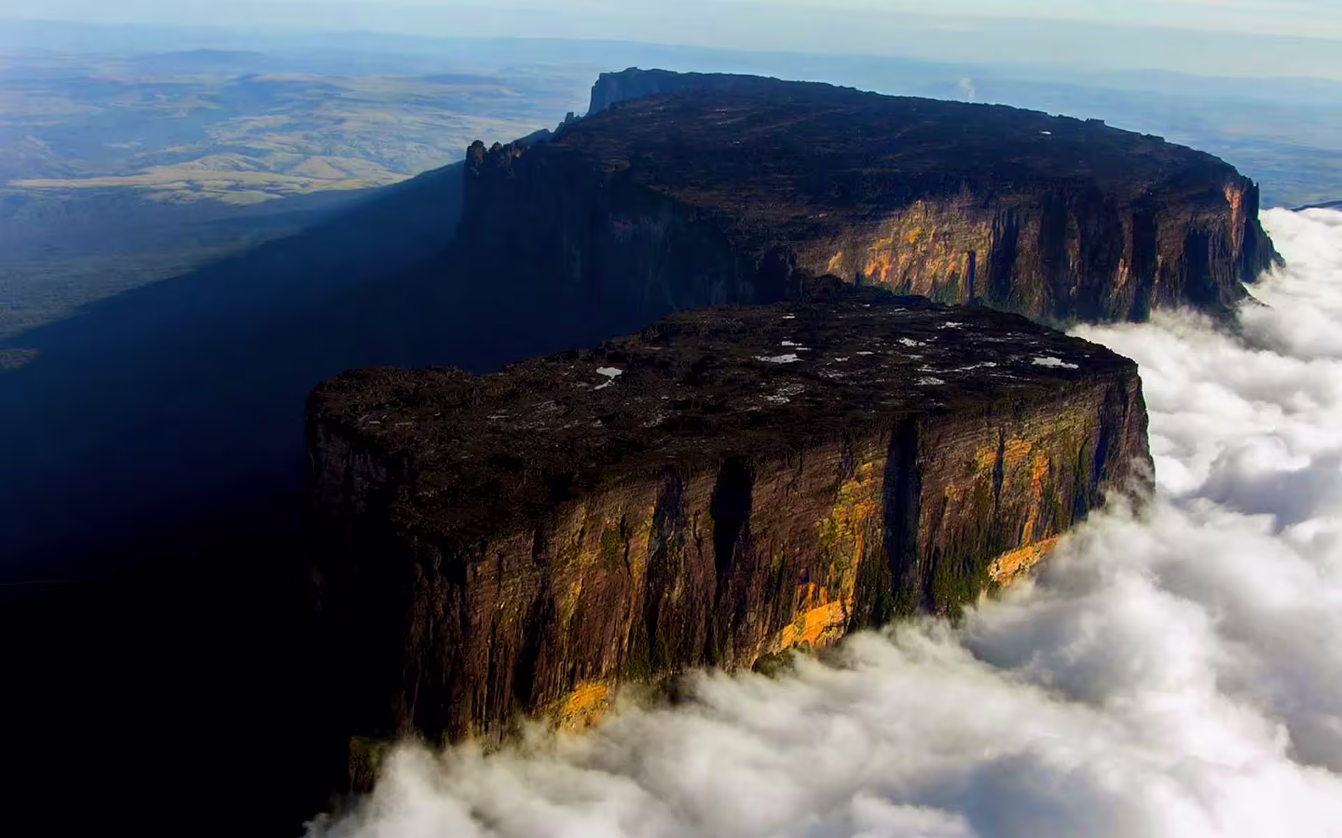
Mount Roraima (Spanish: Monte Roraima; Tepuy Roraima; Cerro Roraima; Portuguese: Monte Roraima) is the highest of the Pacaraima chain of tepuis (table-top mountain) or plateaux in South America. It is located at the junction of Brazil, Guyana and Venezuela. A characteristic, large, flat-topped mountain surrounded by cliffs 400–1,000 m (1,300–3,300 ft) high, its highest point is located on the southern edge of the cliff at an elevation of 2,810 m (9,220 ft) in Venezuela. Another protrusion at an elevation of 2,772 m (9,094 ft) at the junction of the three countries in the north of the plateau is the highest point in Guyana. The name Mount Roraima came from the native Pemon people. Roroi in the Pemon language means "blue-green", and ma means "great".
Leaching caused by intense rainfall has shaped the peculiar topography of the summit, and the geographical isolation of Mount Roraima has made it home to much endemic flora and fauna. Western exploration of Mount Roraima did not begin until the 19th century, when it was first climbed by a British expedition in 1884. Yet despite subsequent expeditions, its flora and geology remain largely unknown. The privileged setting and relatively easy access and climbing conditions on the south side of the cliffs make Mount Roraima a popular destination for hikers.